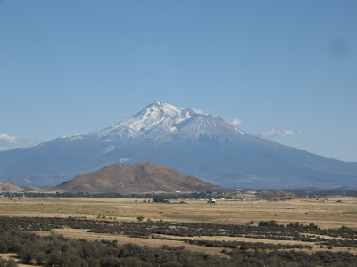
Wednesday, September 26, 2007


Yosemite
Great time in Yosemite these last couple of days. I had been there once before and am getting ready to settle down for a while, so the visit was pretty quick. Even so, I saw more than I remember seeing the first time.

I started off with a short walk to a view of Bridalveil Falls.

Then, to Yosemite Falls. Again a short walk to the base of the lower falls, where I supposedly would see a dramatic falls with lots of water dropping over 2400 feet. Unfortunately, fall is not the best time to look at waterfalls. There was just a small drizzle, as explained by the sign below.

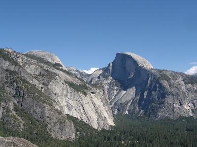
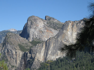
So much for waterfalls, but there was a trail to the top of the upper falls with some excellent views of Yosemite valley. It has about 2700 foot elevation gain...more than I wanted to tackle at this point. But Columbia Rock, halfway up, was rumored to have some great views as well. Sure enough, I took this photo of Half Dome and North Dome.

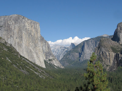
Next, it was up to Tunnel Vista, an overlook on the opposite side of the valley. Great views of El Capitan on the left, and Half Dome in the center. Also a better view of Bridalveil Falls.

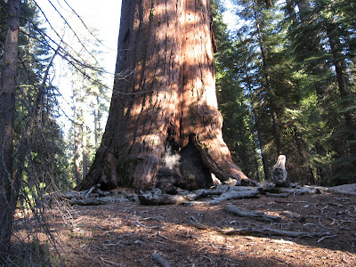
Finally, to Mariposa Grove of giant Sequoias. I took a loop trail around the grove, where I saw many Sequoias and learned a bit about them. The largest (about 15 feet diameter) and oldest of them was Ol’ Grizzly. It is over 2000 years old. Can you imagine it was around at the time of Christ!? Sequoias can live to be about 3000 years old.

Almost as amazing, after these redwood trees fall, they are so insect and rot resistant that it can take them up to 1000 years to disintegrate. This tree fell about 300 years ago! 
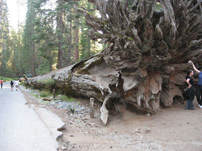
After a couple of days camping, I was ready for a shower, a bed and some TV and computer time, so it was off toward Southern California. I made it as far as Palm Springs tonight and expect to head over to Big Bend NP over the next couple of days.

Sunday, September 23, 2007

Washington, Oregon, California

After leaving Montana I drove across Idaho to Washington.

I stopped at a Rest Area, and took this picture of Mount Rainier from there, about 75 miles away.

The Pacific Crest Trail near Mount Rainier was on my agenda, so I headed there next. I found the Pacific Crest Trail about 10 miles east of Rainier and hiked south for a bit near Chinook Pass. I took the following photo of Mount Rainier from a side trail from the PCT, since the PCT runs on the opposite side of the pass from Mount Rainier. The glacier on the NE side of Rainer is the largest in the lower 48.

Unfortunately, the road through Mount Rainier NP from this point was closed, so I had to backtrack to the south side of the park to set up camp in the park. I took this picture from the south side of Rainier.

The next morning, the mountain and any long vistas were covered by clouds and the forecast was for more of the same for the next two days, so I headed to my next point of interest, Mount St Helens, which was just a few miles south. Amazingly, this drive, which was less than 100 miles took most of the day, because the road was small and winding. Here is a picture of the road, which is typical of this part of Washington, Oregon and California, mainly spruce and Douglas Fir forests.

Mount St Helens was mostly covered by clouds, but I did get this partial from about 10 miles away. Amazingly, even at this distance the trees were dead from the force of the blast 27 years ago.

After a night in Cottage Cove, Oregon, I visited the Church there and set off for California. I took this picture of Mount Shasta from a rest area shortly after I entered California. Next stop, Yosemite.

Wednesday, September 19, 2007

Glacier Many Glacier. I love Montana, but it is time to go.

I know that being an explorer sometimes requires a certain commitment to “roughing it”. So, when I left Kalispell for Glacier on Sunday afternoon, I accepted a forecast for cool, wet weather for several days along with a reservation back in Kalispell for Thursday night as a reasonable risk of incurring some discomfort and a commitment to stick it out for four days. It started with rain before I reached the park.

Someone at church had told me I should be sure and see the inside of some of the lodges while I was at the park, so I had made a note to self about visiting on a rainy day. So, after setting up the tent in the rain, I headed for the Many Glacier Hotel, just a quarter mile away. What I found was a warm, welcoming lobby with a massive fireplace, reading areas overlooking the lake and a Hootnanny in progress. There were a couple of cabaret/comedy acts along with a professional piano player and fiddler. Great show, and warm, comfortable surroundings…hey, at Glacier even explorers don’t have to put up with hardship all the time!

Monday arrived partly cloudy, so I decided to take my first hike, to Cracker Lake. The Ranger had suggested it when I couldn’t get the Highline Trail, but at the time I couldn’t remember anything about it. After looking at my guide I decided to give it a go. It is about 11 miles with 1200’ elevation.

Here is a sampling of the view along the trail. I’ve given up trying to identify all the mountains.

I did see 3 moose…a bull, cow and calf. Unfortunately, by the time I got my camera out I could catch only one.

Here is a picture of Cracker Lake, with Mount Siyeh behind. The vertical face you see is the tallest vertical cliff in the lower 48, according to Backpacker magazine, at 4200’. For reference that is about 420 stories tall. I’m not sure how much of it we missed, because the clouds were moving in, covering the top. Moments later, the rain started and the hike home was long, cold and wet.

Here is a picture back along the trail toward my campsite, through the valley and around behind the mountain to the left.

After changing to some dry clothes, I remembered mental note to myself #2… the hotel probably has a restaurant. Indeed, they do. The Rocky Mountain Trout, slightly crisped in garlic butter on a bed of rice/walnut pelaf was excellent, and again the warm fire in the lobby was quite a luxury.

Again, Tuesday broke with a mix of sun and clouds, so I decided to hike to Grinnell Glacier, a hike of a bit over 11 miles with about 1600’ elevation. Again, a couple of views from the trail, of Josephine Lake with Gem Glacier and Salamander Glacier and back along the trail of Josephine Lake, Grinnell Lake and Swiftcurrent Lake strung out from near to far. My campsite was just at the other end of the far lake, Swiftcurrent.

On this trail, I saw 3 Bighorn Sheep grazing along the mountainside. I managed to capture two in this picture. Maybe you can pick them out.

Here is a closer picture of Gem Glacier. If you look closely you can see there is a man standing near the lower left side, on the Glacier.
The destination is a group of Glaciers. Gem, the small, round Glacier at the upper left is the deepest in the park. The long, narrow, horizontal glacier is Salamander. The large Glacier touching the lake (Upper Grinnell) is Grinnell Glacier. It is the largest in the park, covering about 300 acres. (Gem and Salamander are above Grinnell, and are covered by the clouds. Just a few years ago, all three glaciers were a single, large Grinnell Glacier. The milky color of Upper Grinnell lake is due to the dust particles which the glaciers grind from the mountain. You may notice the clouds gathering as I snapped the closeup of Grinnell. Yep, just as I reached the top, the clouds moved in. But, this time, it is sleet, turning to rain as I descend. And, it was accompanied by thunder and lighting.

After changing to dry clothes, I remembered mental note to self #3. Several people, backpackers, people at the lodge, people at the KOA had mentioned that I should really eat at the Park CafĂ©, a local establishment just outside the park, and to be sure and have a piece of pie. I arrived to discover this was their last night… they were closing for the season within hours. They were out of almost everything, but the Nachos Grande were great, and I got their last piece of pecan pie. That “roughing it” stuff is overdone.

Meanwhile, back at camp in the rain, I began thinking about mental note to self #4. They probably have rooms at Glacier Hotel, seeing as this is their last week of the season….Whoa, the $130-250 per night price tag put that one to death. Besides, my trusty Kelty 20 degree bag has kept me toasty warm so far.

The precip continued all night, and indeed I was toasty. But, in the early hours of the morning I realized my tent was getting smaller. Investigation revealed that 2-3” of wet snow had collapsed it. Once I brushed the snow off, the tent immediately popped back up and I continued my sleep, occasionally waking to pop the snow off. But, when the snow continued at 10:00am, and the forecast called for more of the same, I called it quits. I packed up and headed for Kalispell a day early. Some roads were closed, but I eventually managed to make it to Kalispell and change my reservations. So, all is well. I love Montana, but,as you can plainly see below, it is time to head for Washington.

Saturday, September 15, 2007

Glacier Gunsight Trail

Well, another hike, another set of amazing vistas, but I wasn’t able to do the 2 night, 3 day hike on the Highline Trail because all the backcountry permits for that area were already booked. So, I fell back to my #2 choice, a similar trip on the trail to Gunsight Pass. I hiked to the Gunsight Lake Camp Area on Thursday, then hiked up to the Gunsight Pass on Friday. Finally, back to the trailhead on Going to the Sun Road today. This trail actually starts at the overlook of Jackson Glacier that I showed in a photo earlier and ends up about 4-5 miles closer. I took the following picture of the Glacier from the trail.

I actually was closer to it when I tried the Jackson Glacier trail from camp, but did not complete this trail to get a better view because it was very steep, overgrown and full of signs of bear activity. I did take this view from near my campsite. It shows Jackson Mountain on the left (the Glacier is on the other side of the mountain and not visible from here) and Gunsight Pass in the low saddle in the center. Gunsight Mountain is on the right.

The hike up to the pass was about 6 miles roundtrip, ascending about 1700 feet. By camping at Gunsight Lake both nights I avoided carrying the full pack up to the pass. As usual, the views were great from the pass. Here is the view looking west, of Ellen Wilson lake and various mountains in the background. On the last night I had several backpackers come over the pass and camp at Gunsight lake because a bear had been harassing them at Ellen Wilson, sniffing around the tents 2 nights in a row. On my hike back today I met a ranger who was putting up a sign closing that area. Again, I didn’t see a bear, but the other couple in the area told me an hour or so after I went to bed a black bear walked through our camp area.

Looking back to the east from the pass, you had a great view of Going to the Sun Mountain in the center and Fussilade Mountain in the foreground on the left. Matahpi Peak is the sharp triangle between the two.

On the trail coming back from the pass, I took this picture of the trail and Gunsight Lake below. My campsite was near the far end of the lake.

I saw some raptors, one of which I think might be a bald eagle, but it was too far away to get a good look or photo. I saw some more mountain goats and of course the usual collection of squirrels, marmots and birds. But, probably the most interesting wildlife were a herd of half dozen or so mule deer who grazed up to camp each night as we were having our evening meal. They were quite tame, venturing to within 10-20 feet of us. Here are a couple of them.

Also along the trail I took this photo of a sharp ridge that I believe is part of Dusty Star or Almost a Dog Mountain and this photo of Deadwood Falls.

Again, a spectacular sight around every corner, but I’m cutting back on the photos because they are so time consuming to load.

Tonight I’m enjoying a night with a real bed and shower, not to mention TV and WiFi, and plan to head back out to the park tomorrow. Hopefully, the weather will cooperate. So far, the weather has been great with hardly a cloud in the sky most of the time, but a front is supposed to come through on Monday and cool things down, as well as increase the chance of rain/snow for a couple of days. Depending on how things look I’ll check into the Highline Trail again and/or go back to Many Glacier for day hikes to Ptarmigan Tunnel or Grinnell Glacier.

Wednesday, September 12, 2007

Glacier Two Medicine and Many Glacier

After a nice night at Kalispell, Mt and a nice stop for worship at the Kalispell Church of Christ, I decided to try Two Medicine, a less visited area in the South of Glacier NP. It turned out to be just as spectacular as Going to the Sun Road.

My first inclination was to take a section of the Continental Divide trail northwest to Pitamakan pass, but this trail was closed due to excessive bear activity. Bears are the big story here, especially now. They are in the extreme eating period right now in preparation for winter hibernation. Also, populations are increasing. Together this is forcing them out into the open more than normal. The papers every day are full of stories of grizzlies being killed by hunters or hit by cars in areas where they are not supposed to exist. Meanwhile, I’ve yet to see one.

I decided to take a similar, nearly parallel trail, the trail to Dawson Pass. I did it out and back on the same day, and it ended up being my most strenuous day yet, about 14 miles and 2500’ climb. I won’t do that again unless I get in better shape…I was toast by the time I got back to camp.

Even so, the trip was well worth the sore muscles. Here are a couple of pictures of Sinopah mountain and the Pumpelly Pillar from the trail at the lower elevations.

This is looking back toward Rising Wolf mountain on the left and Sinopah Mountain and Pumpelly Pillar on the right framing Two Medicine lake. My campsite is on the other side of Rising Wolf.

Another view of Pumpelly Pillar. This is a narrow ridge cut by glaciers on either side.

Here is the view from Dawson’s Pass. First, looking south toward Caper Peak, Battlement Mountain and Mount St Nicholas. Then looking north toward Norris Mountain, Triple Divide Peak and Medicine Grizzly Peak. Finally, looking straight ahead to the west, Nyack Lakes and Phillips Mountain and Surprise Pass.

Day two at Two Medicine I hiked a short trail to Running Eagle Falls, also called Trick Falls, because of the way it just appears out of the side of the mountain. The stream runs into a cave above and comes out here.

I also hiked a short distance southwest on the Continental Divide trail toward Scenic point. I did not make the full 2250’ climb due to tiredness from the day before, but I took this picture back toward the campsite with Rising Wolf Mountain in the center and Dawson Pass to the left.

After 2 days at Two Medicine, I decided to move to Many Glacier, another famous area on the east side of Glacier NP. I hiked to Red Rock Falls, and took this picture of the falls and of the view back toward Many Glacier from near the falls. Also, I took this picture of the Many Glacier Hotel across Swiftcurrent Lake.

I had plans for another strenuous hike to Ptarmigan Tunnel or Grinnell Glacier today, but a front came through last night and it is cold, cloudy and rainy today, so I decided to get a cabin at the St Mary/East Glacier KOA tonight and file this report. Assuming it clears up, tomorrow I hope to hike the Highline trail by the Garden Wall to Granite Park and spend a couple of days exploring that area.

Saturday, September 08, 2007

Glacier National Park, Road to the Sun

After five and half days of driving, I was beginning to wonder if Glacier would be worth it. After the first day here, I knew it was. The park is really spectacular. It is also clear I made the right decision to get here as quickly as I could, since the Going to the Sun Road, the main road across the park, will close for the winter on September 16. Most of the campgrounds close by September 15, although some at the lower elevations around the perimeter are open all winter. For more visual evidence that I got here just in time, take a look at the picture below. This is a picture of Red Eagle Mountain, taken from my campsite this morning. When I arrived, there was no snow on the mountain. This blanket of snow arrived on Friday afternoon and evening.

The park is formally called the Waterton Glacier International Peace Park. Waterton park was established by Canada in the 1890s and Glacier was established by the USA in 1910. They were combined in 1932 and renamed to reflect our friendly and peaceful relationship. Unfortunately, today, I can’t visit the Canadian part of the park without a passport.

Going to the Sun Road must be the most scenic road in the country. I decided to focus these first few days on this road and short (up to 5 miles) trails from it. Below is Going to the Sun Mountain, one of the highlights of the road, of course.


Glacier Park, as you might guess, was formed by glaciers. These are retreating, but many still exist. Below is Jackson Glacier.

I hiked Hidden Lake trail and took these pictures of mountain goats and Hidden Lakes/Sperry Glacier from Hidden Lake Pass.

Then I spotted these Bighorn sheep near Logan’s Pass.

On day 2, I hiked a short section of the famous Highline Trail, shown below. I hope to take a longer hike on this trail later.

I also hiked the Avalanche trail. Below is a picture of Avalanche Lake where Avalanche Falls drops into the lake, and Avalanche Gorge, a narrow gorge cut by exit of the water from Avalanche Lake.

Finally on day 2, are pictures of McDonald Falls and McDonald Lodge. Glacier is unique in that there are many lodges build in Alpine style in the 1920s. I happened to catch McDonald Lodge with three 1937 Cords parked in back, along with typical classic tour coaches (Red on Left) still used in the park. This is all in the back, since there were no roads when the lodge was built. The front faces lake McDonald, where guests arrived by steam boat on Lake McDonald, after a train and stage coach ride to the other end of the lake.

On day 3, today, I took the picture (top) of Red Eagle mountain from my campsite, and the below picture of Red Eagle from Sun Point over lake St Mary.

Then I hiked to St Mary Falls and took this picture below before stopping again at Lake McDonald to take the picture of mountains and clouds over the lake.


Then, I beat it to Whitefish to try to catch the A&M/Fresno State game. Unfortunately, all the hotels in Whitefish were booked, so I talked the sweet young thing at the desk into letting me use the TV in the Lobby, since the game was already underway. The local papers showed the game would be on, but it was preempted by a Boise State game!

Never to be denied, I booted up WiFi from the parking lot and am listening to the game on the internet at Aggie Athletics while posting this report. I’ll find a hotel later and plan to head back to the park tomorrow after church.