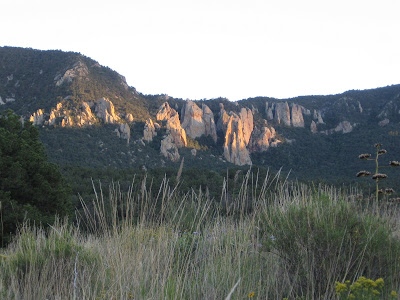
After traveling through 18 states, I’m finally back in Texas. I came in from the west, so I decided to visit the Big Bend NP in southwest Texas, one of the most remote national parks. Despite what the calendar says, fall has not arrived in SW Texas. At low elevations temperatures were around 100 degrees. Fortunately, Big Bend features the Chisos Mountains. I camped in the Chisos Basin, a bowl at about 5400’ elevation surrounded on all sides by the Chisos Mountains. Temperatures here were very pleasant. Most of my hiking was between 6000-7200’. Below is a picture of the Chisos Mountains from about 20 miles away. The South Rim is to the left side of the mountains.

As I mentioned, Chisos Basin is surrounded by mountains. All drainage in the basin exits through the lowest point in the perimeter on the NW side, called the Window. Back in 1981 I hiked to the Window, so this time I settled for a picture from the Basin. You can see the Christmas Mountains through the window, about 30 miles away.

The mountains to the south of the Basin form a popular hiking area known as the South Rim. Here is a view looking south from the Basin.
I hiked the Laguna Meadows, SW Rim, South Rim, Boot Canyon and Pinnacle trails to see views to the SW and SE of the Chisos mountains across the Rio Grande river into Mexico, about 30 miles away. You can see the Sierra del Carmen mountains up to 50 miles SE in the first picture and the Santa Elena Canyon to the SW in the second.

I also took this picture looking back toward the Basin from the trail.

Here is a closer view of the Sierra del Carmen, from about 10 miles away. The Rio Grande cuts the Boquillas Canyon between the mountains in the part of the range in the US in the foreground and the Mexican part in the background.

Here is a picture of the Rio Grande river at Boquillas Canyon. I decided not to swim the river as I did in 1981. Yes, indeed, I am a wetback, twice (over and back). It was common in those days, but Border Patrol is everywhere and pretty stern about it these days. Since I was here in the 80s the Rio Grande has been designated a Wild and Scenic River by the US.

Of course, many Mexicans don’t have a problem with crossing. I saw two places on the trail where Mexican goods were laid on the side with a note asking you to purchase or donate (on the honor system) their products for the good of the children of Boquillas village in Mexico(must be related to Nancy Pelosi). Just before I turned the corner in the trail to find this cache, I would swear I heard voices, but no one was visible when I arrived. Pretty eerie. Being here and seeing the hundreds of miles of remote, unpopulated border reinforces my opinion that closing the border is an impossible task. Next stop, central Texas.
I also took this picture looking back toward the Basin from the trail.
Here is a closer view of the Sierra del Carmen, from about 10 miles away. The Rio Grande cuts the Boquillas Canyon between the mountains in the part of the range in the US in the foreground and the Mexican part in the background.
Here is a picture of the Rio Grande river at Boquillas Canyon. I decided not to swim the river as I did in 1981. Yes, indeed, I am a wetback, twice (over and back). It was common in those days, but Border Patrol is everywhere and pretty stern about it these days. Since I was here in the 80s the Rio Grande has been designated a Wild and Scenic River by the US.
Of course, many Mexicans don’t have a problem with crossing. I saw two places on the trail where Mexican goods were laid on the side with a note asking you to purchase or donate (on the honor system) their products for the good of the children of Boquillas village in Mexico(must be related to Nancy Pelosi). Just before I turned the corner in the trail to find this cache, I would swear I heard voices, but no one was visible when I arrived. Pretty eerie. Being here and seeing the hundreds of miles of remote, unpopulated border reinforces my opinion that closing the border is an impossible task.
Next stop, central Texas.
2 comments:
Reminds me of my trip to Big Bend a few years ago. We met with similar temperatures in the Spring, but like you said, it wasn't too bad once we got to elevation. We did the same trails-- Laguna Meadows, Southern Rim, and Pinnacle. It really is amazing how remote it is.
Reminds me of my trip to Big Bend a few years ago. We met with similar temperatures in the Spring, but like you said, it wasn't too bad once we got to elevation. We did the same trails-- Laguna Meadows, Southern Rim, and Pinnacle. It really is amazing how remote it is.
Post a Comment